Teren for Windows
Description, features, system requirements etc.
Description
Teren is a Windows based application for field seismic survey. It had been primarily used for field notes but has later grown to a database software and basic seismic data manipulation. The name originates
from the word teren (eng. terrain), which in general also means a field survey in slovenian language. There is no need for field notes and complicated and confusing sheets and reports.
Teren simplifies
the field work and collects both metadata and the measured data into a single database. All the data are unified into projects, which are organised by the date created and data measured. The projects themselves
or their individual components (seismic lines, measurements, records etc.) can be exported to another PC for further data manipulation very easily, thus migrating the data from the field to the office. Only
2D seismic lines are currently supported.
How it works
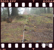
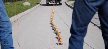
A meter tape on the filed is recommended to get consistent geometry and record assignemnts by Teren applicaton. Instead of confusing and time consuming field notes the user can control the seismic measurements and
store the information into the database directly on the field. The collected data can be then transported to another PC in the office.
By moving the seismic spread the positions of the active geophones
are automaticaly calculated and assigned following the tape or any other field meter markings.
The seismic records can be imported into the database in regard to the measured filed information. If using
a third party seismic acquisition software, such as Summit X One Data acquisition, the records can be automatically imported into Teren database during the field work.
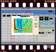
This way additional options are available during the acquisition process, such as dispersion image creation (MASW), data quality control, first breaks assessment etc.
Main features
- responsive to almost any display resolution
- suitable for shallow refraction, MASW, downhole
- storing records, stacks and field notes into a single database
- data are collected in projects and surveys which can be imported or exported between computers
- records can be either imported or copied automatically by monitoring a folder (compatible with Summit X One System or any PC based data acquisition application)
- support for most SEG2 binary formats (SEGY not supported)
- SEG2 file traces manipulation (mute, reverse, delete)
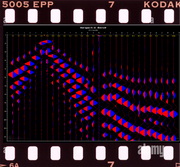
- multiple SEG2 file display combination to clearly identify S-arrivals
- geometry input for consistent trace tracking
- on-site dispersion image creation (MASW) and first breaks picking (internal or external software)
- data preparation for export to some known formats for further processing (tomography, inversion etc.)
- basic processing and evaluation (plus-minus, delay time, 2-layer and 3-layer)
- static corrections calculation
The following shallow geophysical seismic methods are currently available in Teren application:
- Refraction/reflection module (REFRAK)
- Downhole survey module (DH)
- MASW survey module (MASW)
- Horizontal to vertical spectral ratio (HVSR, experimental)
- Walkaway module for noise-test survey (Walkaway)
- Literature module (experimental) to store additonal documentation, literature etc. (separate database)
System requirements
- Windows based laptop or desktop PC computer
- Operating system: Windows 7, Windows 10 and above
- min. 2 GB RAM
- min. 20 GB Hard disk space (for large and multiple SEG2 files)
- (optional) using Summit X One system: Summit X One Data Acquisition software
- (optional) external first break picking (Interpex Ixseg2segy recommended)